About
- Bringing together the expertise of the two countries, the MARINEGEOHAZARD project aims for the establishment of a joint regional early-warning system and of a common decision tool, which can support in an efficient manner the emergency managers and decision makers in their activity related to protection of the local communities, environment and assets within the cross-border area, from consequences of natural marine geohazards.By targeting the most vulnerable cross-border area of the Black Sea coast – where the cautious exploitation and effective protection against risks is a prerequisite and where the present lack of any prevention system to natural marine geohazards could lead to a general disaster – MARINEGEOHAZARD is addressing the needs, for conservation and protection of the environment, including prevention of natural and technical risks, and coordination of emergency responses at cross-border level.
Through the system foreseen to be implemented, the project joins forces and eliminates duplication of national efforts related to rapid detection, assessment and notification of marine hazards, providing thus a unique, economically efficient and sustainable, cross-border infrastructure, shared and operated jointly by the two countries, for the mutual benefit of the population from the border area. Moreover, by connecting the newly created early-warning system for marine geohazards with existing national networks (such as the national seismological network) and by integrating the data and unifying them into single database, and by interlinking the related technical and scientific capabilities from the two countries, the project finally results in the set-up of a strong, cooperative cross-border structure that will underpin and support the further integration of national emergency plans and coordination of mitigation strategies from the cross-border area.
Representing the conjugated effort of the two neighbor countries to address, in a coordinated manner, a common threat from the cross-border region (a natural marine risk unlimited by artificial barriers such as state’s borders), the MARINEGEOHAZARD project is following entirely the core element of the CBC Programme strategy, which is “cooperation focused on problems where cross-border action is a key requirement”.
MARINEGEOHAZARD Objectives:
MARINEGEOHAZARD represents the first major initiative to address in an integrated and coordinated manner the establishment of a geohazard early-warning system for the Black Sea.
Having as strategic objectives to develop in the cross-border area the early-warning capabilities to marine geohazards, the project will stimulate and foster regional collaboration, underpinning the development of a Black Sea regional system in-line with ongoing European and intergovernmental initiatives such as GEO/GMES.
General objective:
- Implementation of an integrated early-warning system accompanied by a common decision-support tool, and enhancement of regional technical capability, for the adequate detection, assessment, forecasting and rapid notification of natural marine geohazards of risk to the Ro-Bg Black Sea cross-border area.
Specific objective:
- Define and implement a unified and integrated approach to assessment of marine geohazards of risk for the Romanian-Bulgarian Black Sea cross-border area.
- Install a real-time, fully automatic detection system comprising of deep Black Sea complex measurement stations (gauges), of on-shore marine seismicity monitoring and digitalized GPS stations.
- Implement a common decision-support tool (DST) by provision of unique forecast and assessment software package and development of a joint database of scenarios, to facilitate and support management and mitigation of marine geohazards.
- Create the regional technical capability to perform marine seismic measurements.
- Prepare joint, updatable databank by integrating the existing national data, the real-time data from deep-sea gauges and the on-line data from sea-level gauges, remote sensing and national seismographic networks and by performing coordinated marine geohazard investigations to fill-in the lacking data.
- Cluster and enhance the regional expertise by training the staff and establishment of data exchange platform between national institutions.
MARINEGEOHAZARD Funding:
Funding: European Structural Funds (sigla +slogan)
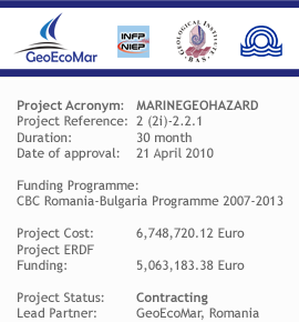
Programme: CBC Romania-Bulgaria Programme 2007-2013 (sigla+slogan)
Project budget (EURO)
|
Amount |
|
| Total Value |
6,748,720.12 |
| Eligible value, of which: |
5,969,327.26 |
| ERDF |
5,063,183.38 |
| National Cofinancing, of which: |
906,143.878 |
|
Romanian State Budget Contribution |
606,128.544 |
|
Bulgarian State Budget Contribution |
169,884.000 |
|
Own Contributions of Partners |
130,131.334 |
MARINEGEOHAZARD Structure:
- Advisory Board
- Steering Committee
- Workpackage leaders
- Task leaders
MARINEGEOHAZARD Workplan
|
Activity |
Starting date |
Completion date |
| Overall project management and coordination |
M1 |
M30 |
| Establishment of a coordinated approach to marine geohazards, based on analysis of each geological hazard of risk to the cross-border area and outline of basic technical specifications for equipment and software of the related Black Sea early-warning system. |
M1 |
M4 |
| Set-up of Black Sea joint early-warning system for the cross-border area through acquisition and installation of real-time detection equipment and data processing and reporting capacity, and of decision support, dedicated software package and database of scenarios. |
M2 |
M30 |
| Developing the required expertise for operation of the early-warning equipment and of the decision support tool, through training of operational staff. |
M18 |
M25 |
| Elaboration of joint, updatable marine geo-databank needed for predicting and managing emergency situations related to geohazards along the Ro-Bq Black Sea cross-border area. |
M3 |
M29 |
| Dissemination of results, information and publicity |
M1 |
M30 |
MARINEGEOHAZARD Deliverables:
Coordinated approach for assessment of marine geohazards: will include inventory of marine geohazards from the Western Black Sea of risk for the Ro-Bg cross-border area; delimitation of related areas of origin for each hazard; joint maps and catalogues of the Ro-Bg cross-border area.
Updatable joint marine geological databank: will comprise all the information needed in the process of elaboration and issue of an early-warning notification, and assessment of evolution of a geological hazard situation, including:
- topography, coastal area occupation, marine infrastructure, bathymetry, lithology, basement geology, structural investigations, tectonics, seismology, etc.
- thematic maps of Black Sea coastal area that will contain detailed information such as: topography of the coastal area and delimitation of areas vulnerable to flooding; sea bottom morphology along the inner shelf area; location and characterization of active areas from the point of view of linear movements (faults) or tectonic blocks (vertical elevation movements, subsidence or tilt).
- catalogue of faults plan solution for each seismic area and digitized catalogue of earthquakes based on integration and re-evaluation of national data and characterization of seismic sources according to international practices and procedures.
Operational joint early-warning system to marine geological hazards of risk for the Ro-Bg Black Sea cross-border area, comprising of following modules:
- network of complex, automatic marine measurement equipment (total no. of 5 gauges) installed in key points of the Black Sea deep area, in water depth up to 1200 m.
These fully automatic stations will be provided with real-time, bidirectional data communication capabilities and will be remotely managed from on-shore; aside of communication and real-time data management capabilities, the operators from Ro and Bg will be provided also with common decision support tools (software) and technical means to perform assessment and forecasting on marine geohazards, based on a common methodology and procedure.
- regional capability for marine seismic monitoring and surveillance comprising of:
- real-time on-shore equipment (3 marine seisimicity monitoting systems, 1 coastal gauge, 5 strong motion seismometers and 5 exnsometers),
- specialized seismic devices operated from the Romanian R/V Mare Nigrum (1 Marine seismic acquisition system with low-frequency acoustic pulse and 5 Ocean Bottom Seismometers) and the Bulgarian R/V Akademic (2 Ocean Bottom Seismometers).
- network of on-line stations for geodynamic surveillance of the Black Sea cross-border area (18 DGPS stations), which will be operated, by the centers in Constanta- GeoEcoMar, Romania and Russe – GI-BAS, Bulgaria which will be provided with same software and data assessment capabilities;
- state-of the art computing capabilities interconnecting the seismic and marine data – from Romania (Constanta – GeoEcoMar and Eforie Nord – NIEP) and Bulgaria (Varna-IO-BAS and Russe – GI-BAS) – so these will operate based on the joint databases, maps and catalogues that will also result from the project.
Decision support tool and database on flooding scenarios of the Ro-Bg coast, will comprise the dedicated software package for assessment of consequences of natural disasters from marine geohazards and rapid notification of emergency authorities from the cross-border area and the database of scenarios (which will include cartographic delimitation of areas that can be affected by flooding, depending on intensity of events taking place in the marine environment -according to Beaufort, Papadopoulos – Imamura scale-, including the events generated directly by geotectonic factors, such as seismic waves and tsunami events).